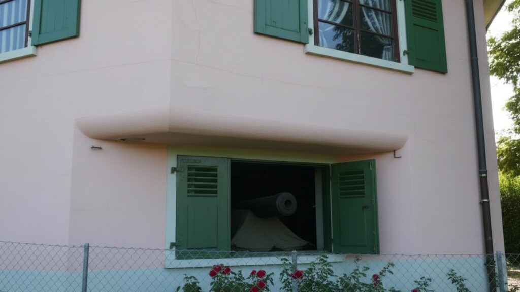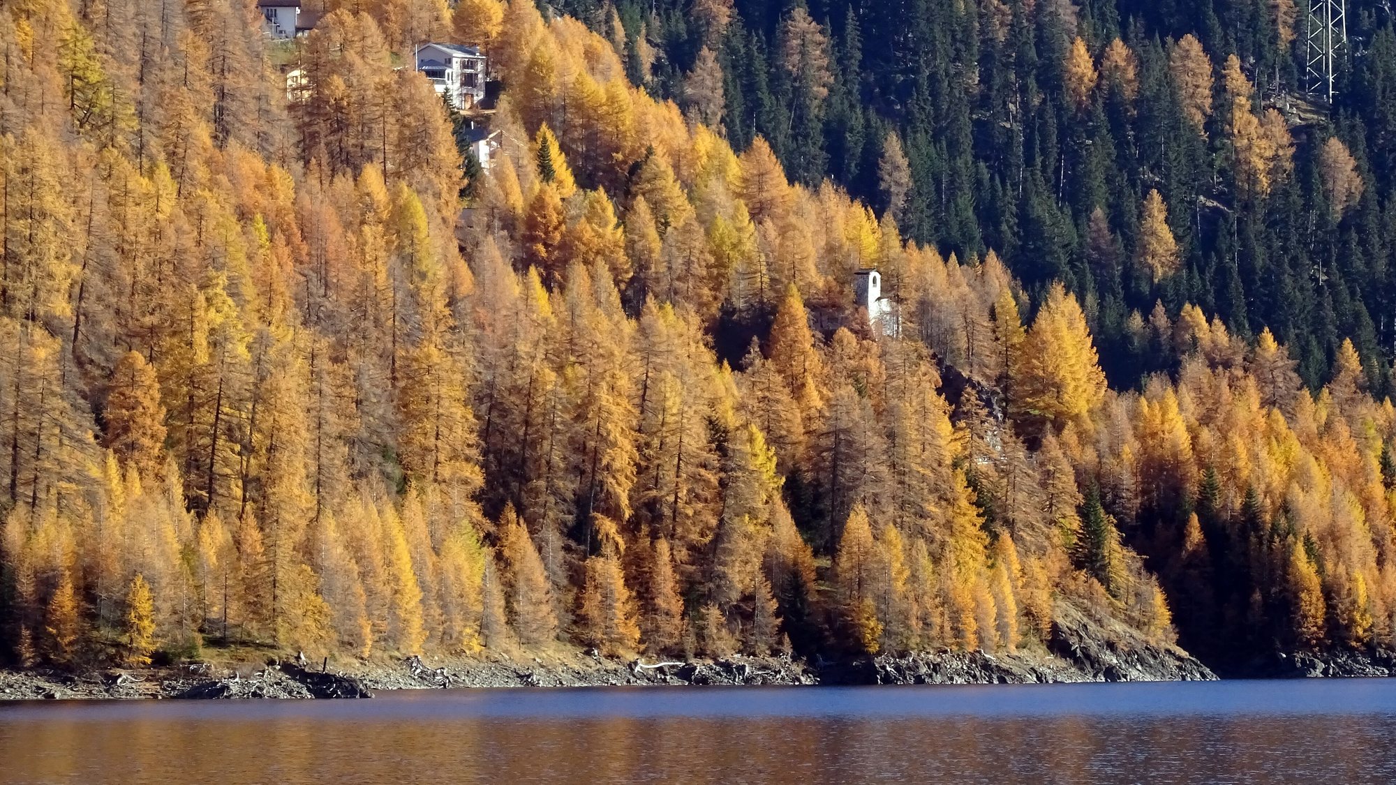
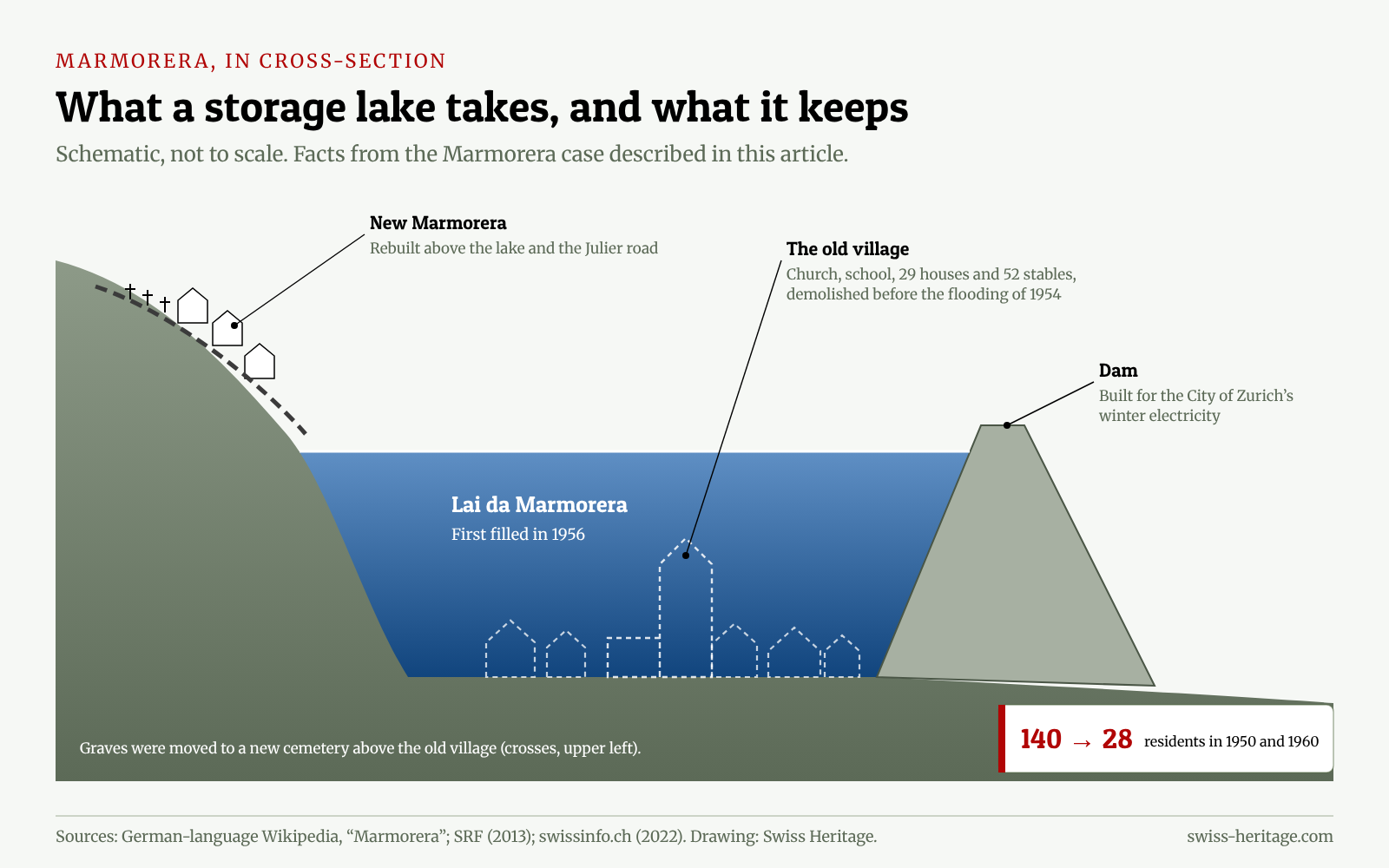
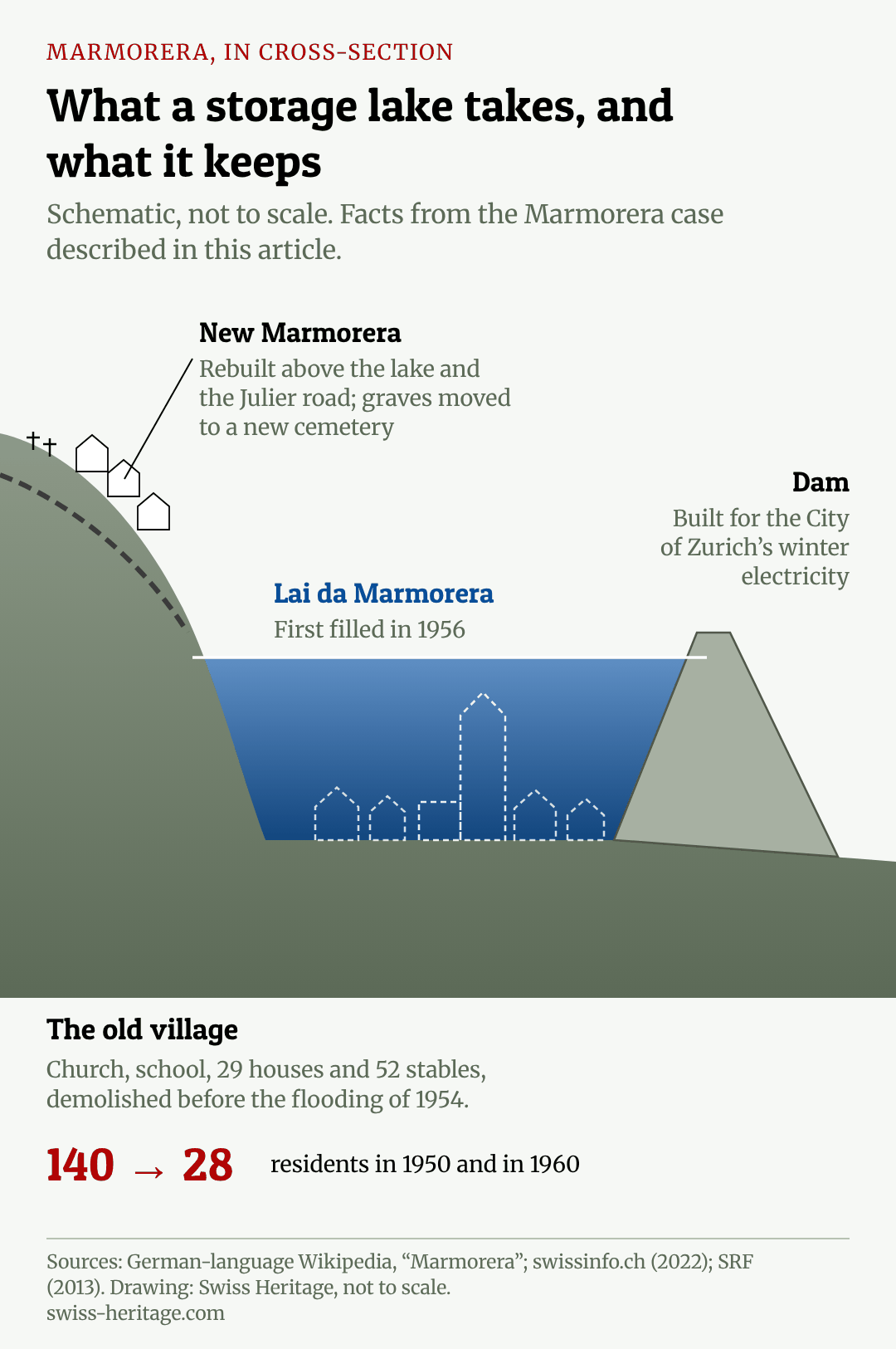
Under the reservoir at Marmorera lie the remains of a village that was demolished in 1954 so that water could take its place. Drivers on the Julier pass road above the lake rarely notice. The new Marmorera stands higher up the slope, small and quiet. In 1950 the village had 140 inhabitants. By 1960 it had 28.
Marmorera is the best-known of Switzerland’s drowned villages, but it is not the only one. Across the Alps and the Prealps, dams built in the twentieth century flooded farms, hamlets and whole villages, and in a few places the people who lived there fought back and won. These are stories most visitors to Swiss lakes never hear, even when they are swimming over them.
They are also the hidden foundation of something the Swiss take for granted. Hydropower still supplies the majority of the country’s electricity. Much of that capacity was built in a single, frantic generation after the Second World War, and the people who paid the highest price for it were mountain villagers who had little else to sell but their valley.
Switzerland’s “white coal”
Switzerland has no coal of its own. In the nineteenth and early twentieth centuries, that made fast-flowing Alpine water an obvious resource, and engineers called it white coal. The federal energy office’s long-term inventory of hydropower plants starts in 1913, when the plants then registered were expected to produce about 3,130 gigawatt hours a year. By 1936 that figure had reached 8,242 gigawatt hours, and the railways were electrified on the back of it.
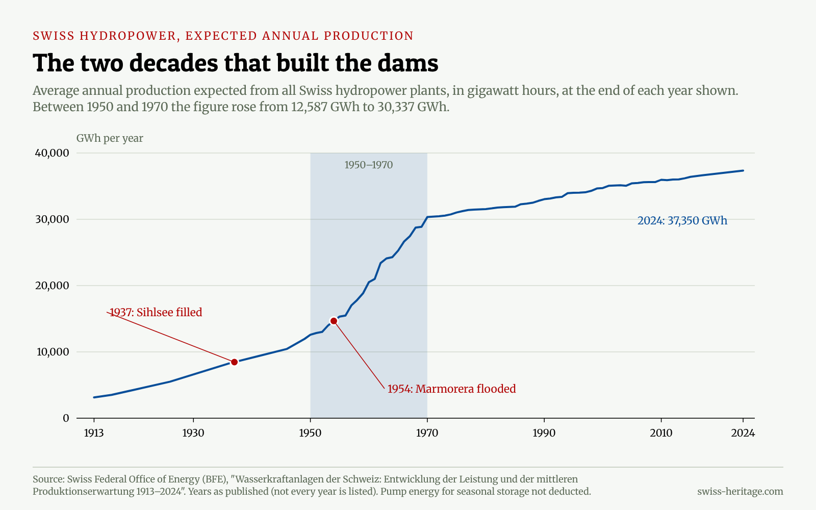
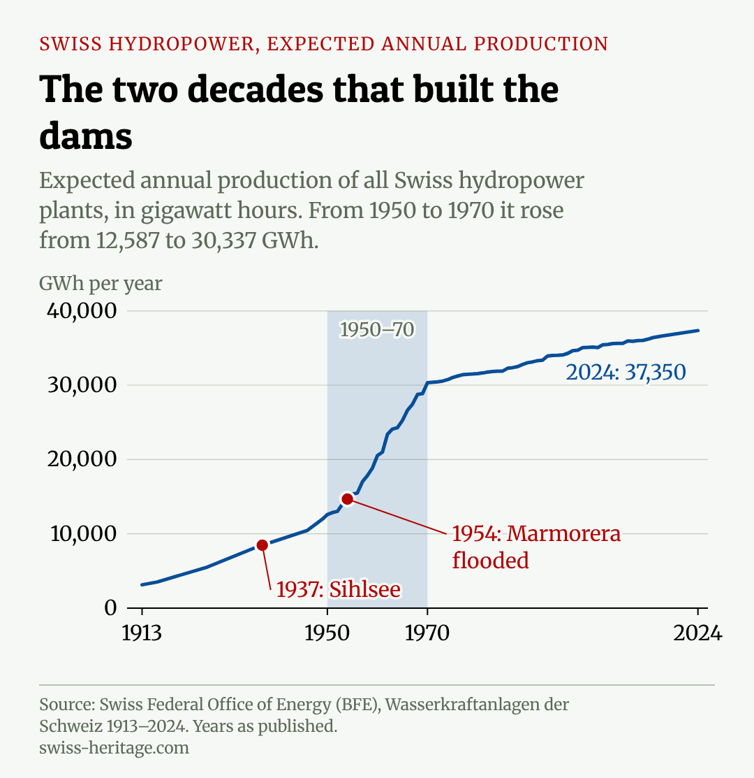
The real leap came after 1945. In 1950, the expected annual output of Swiss hydropower stood at 12,587 gigawatt hours. In 1970 it was 30,337. In twenty years, the country added 17,750 gigawatt hours of hydropower, almost half of the 37,350 gigawatt hours expected in 2024. Every large storage dam needs a valley behind it, and in the 1950s and 1960s the valleys were being chosen at an unprecedented pace.

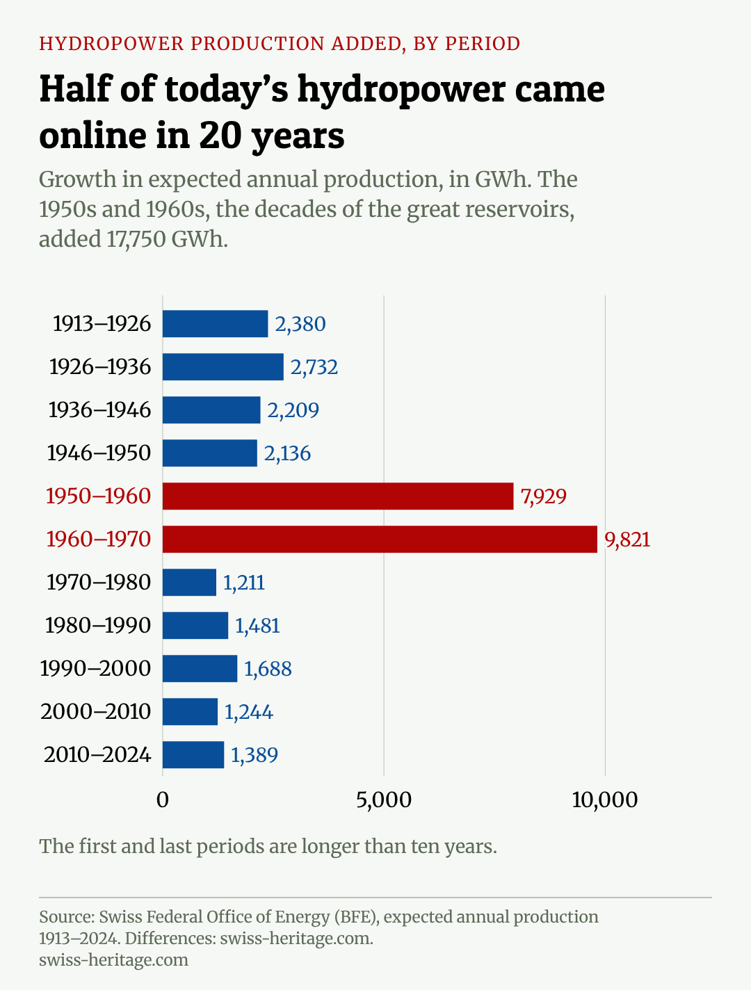
The chart makes the point plainly: no other period comes close. The decades before and after added a few thousand gigawatt hours each. The 1950s and 1960s added almost 8,000 and almost 10,000. It is the era of Grande Dixence, Mauvoisin and the great Alpine dams that tourists now visit as engineering wonders, and it is also the era of most of the flooded settlements. For the engineering marvel that came later on the same principle of mountains made useful, see our guide to the Gotthard Base Tunnel.
Marmorera: a village that voted 24 to 2
Marmorera lay in the Surses valley on the road to the Julier pass, an old village whose German name was Marmels. In the late 1940s, the City of Zurich was looking for winter electricity, and the valley offered an ideal site for a storage lake. Zurich’s negotiator, Walther Pfister of the city’s industrial services, went from owner to owner and concluded individual pre-contracts. According to the German-language Wikipedia account, he asked the owners to keep the terms to themselves.
On 17 October 1948, the municipal assembly approved the concession by 24 votes to 2. It ran for 80 years. Opponents appealed, and the canton of Graubünden rejected the appeal. Contemporary reporting, collected by swissinfo in 2022, records only scattered criticism, such as that of the poet Alexander Lozza. For many villagers in a poor high valley, the money from Zurich was a way out.
The price was the village itself. The dam took the church, the schoolhouse, 29 houses and 52 stables. The graves were exhumed and reburied in a new cemetery above the old village. Some families were offered replacement farms in the distant canton of Thurgau, on the other side of the country. After all buildings had been demolished, the flooding began in 1954; the reservoir was filled for the first time in 1956. A new Marmorera was built above the lake and the Julier road, and the community, by every account, remained divided for years.
What the numbers do not show
The bare figures, 140 inhabitants in 1950 and 28 in 1960, describe an exodus. They do not describe how it felt to watch the water rise over a field your family had cut for hay for generations, or to see a church tower disappear. The Swiss National Museum has used photographs of the relocation work in 1952 and of the reservoir in 1954 to tell the story, and divers still descend to the remains. A village that existed for centuries has been underwater for about seventy years.
Before Marmorera: Innerthal, Eglisau and the Sihl valley
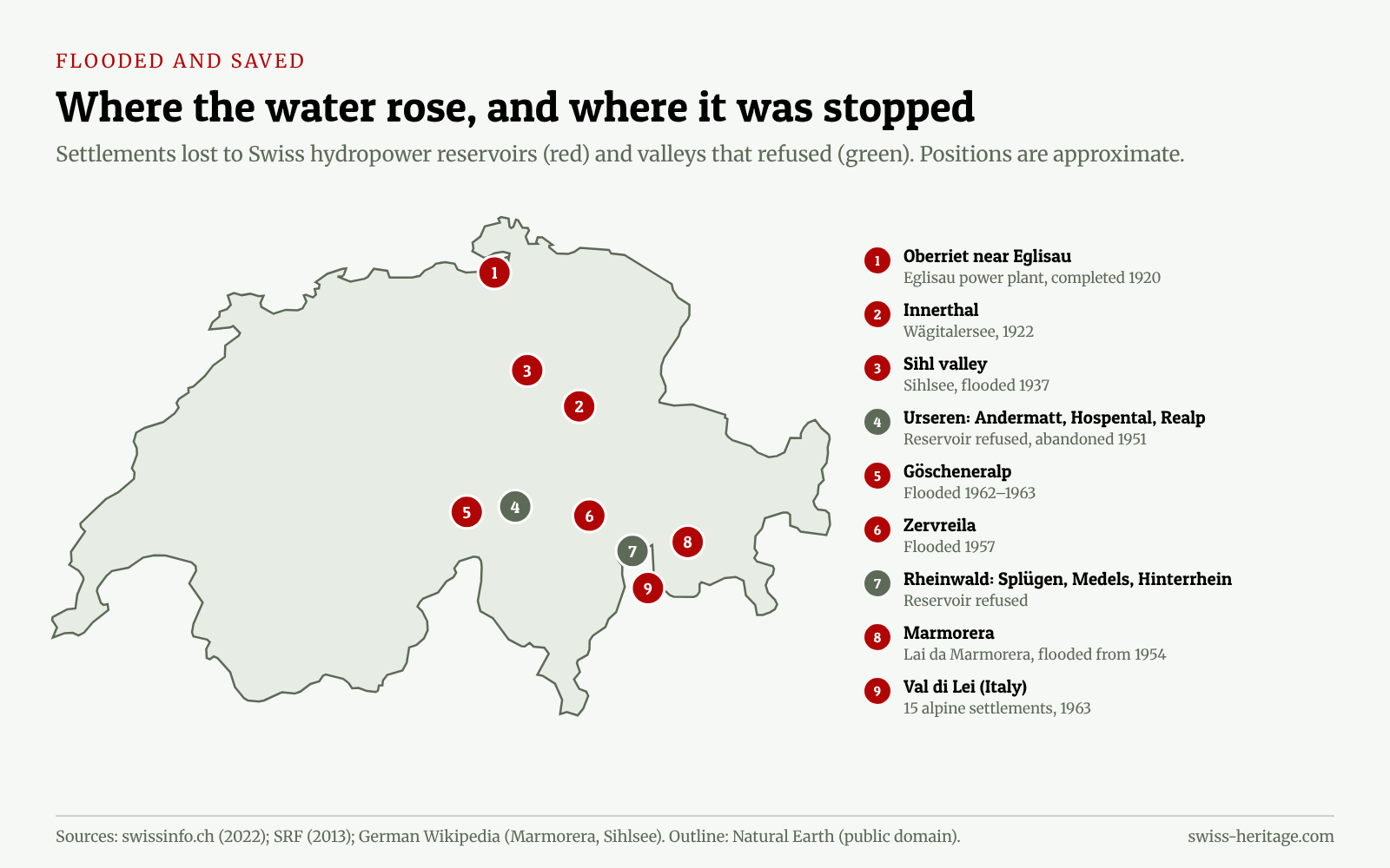
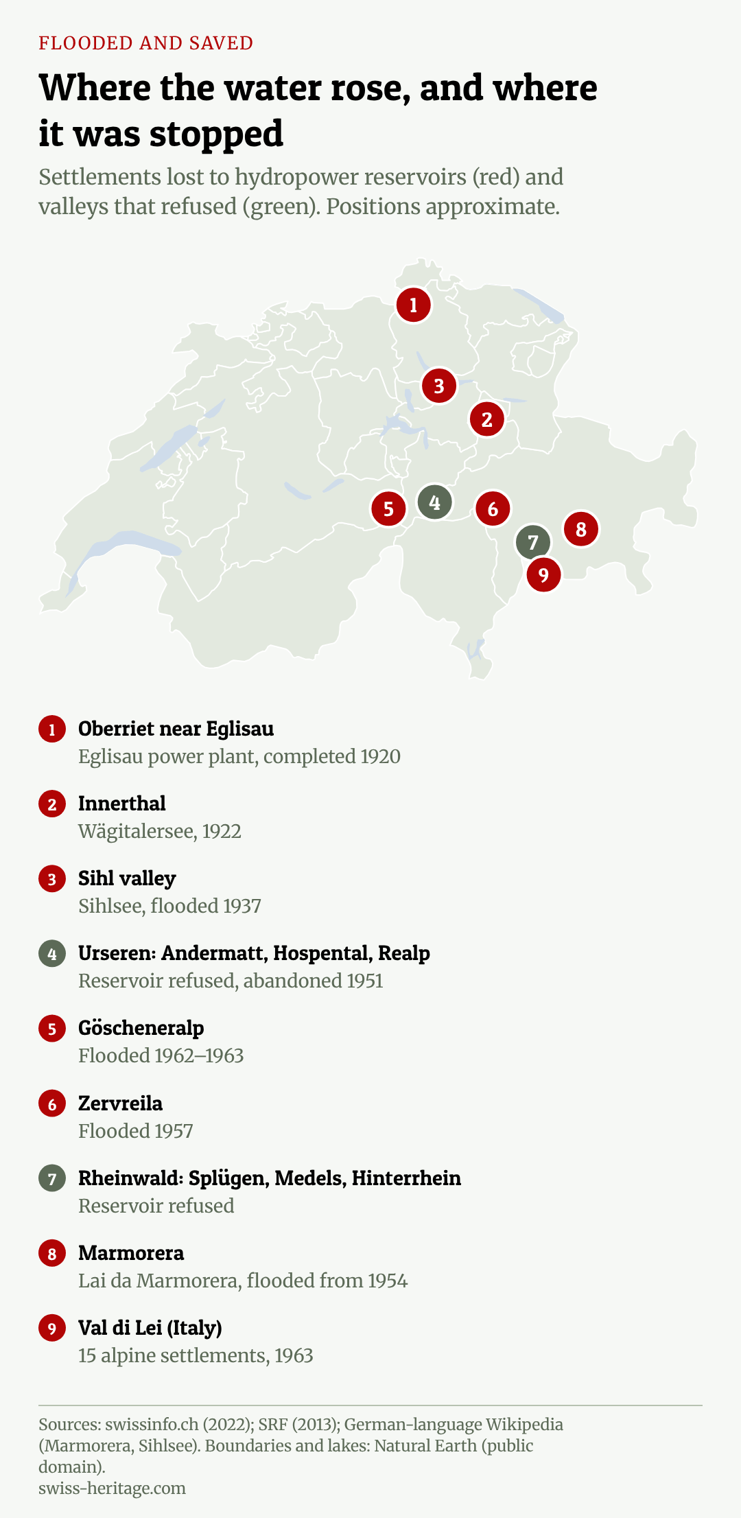
Marmorera came at the end of a longer story. On the Rhine near Eglisau, the run-of-river power plant at Eglisau-Glattfelden, completed in 1920, raised the water level enough to doom the hamlet of Oberriet: 15 of its 17 houses were demolished and about 80 people moved. In 1922, in the Wägital in canton Schwyz, the old village of Innerthal was abandoned for the new Wägitalersee, and its church was blown up.
The largest displacement came in the Sihl valley near Einsiedeln. The Etzelwerk, a power plant for the Federal Railways, needed a storage lake, and in 1926 a municipal assembly approved the contracts with little opposition. Construction began in 1932. Before the water came, the army used two of the doomed farmhouses to test new aerial bombs and then hit the ruins with incendiaries. In 1937 the valley was flooded, and the plant began operating on 23 October 1937.
The losses were large: about 500 people had to leave, and another 1,300 were affected. The new lake covered 93 dwellings, 124 barns, 179 peat huts and 55 farms, along with hundreds of hectares of meadow and peat land. A resettlement project created 30 new farms and houses for 175 people. Some accounts say many displaced families emigrated, and the figures in different sources do not always agree; a swissinfo picture caption gives a number of over 1,700 people affected. Today the Sihlsee, roughly 11 square kilometres of water, is popular for walks and, in winter, for cross-country skiing along its shore, and most visitors have no idea what lies beneath it.
Göscheneralp, Zervreila and the high-alpine villages
The post-war dams moved higher into the mountains. In the Valsertal in Graubünden, the hamlet of Zervreila disappeared under its reservoir in 1957; wood from the flooded houses was later used to build a restaurant above the lake. At Göscheneralp in canton Uri, the dam was completed in 1960 and the valley flooded in 1962 and 1963, displacing about 70 people. Just across the border, in the Italian Val di Lei, 15 alpine settlements were submerged in 1963. When that reservoir was emptied for maintenance half a century later, weathered stone walls, old windows, a kettle and wheels appeared for the first time since the flooding, Swiss television reported in 2013. Göscheneralp, meanwhile, was built partly as a substitute for a much larger project that the people of Uri had refused, which brings us to the most important story of all.
Look at these cases together and a pattern appears. The places that went under were small: a hamlet here, a village of 140 there, a high valley of about 70 people. They were remote, poor in cash and short of alternatives, and their consent could be secured by an assembly of a few dozen voters. The larger and better-connected the community, the harder the deal became. That is not a law of nature, and every case had its own history, but it helps explain why the map of drowned settlements is a map of the margins, and why the most ambitious project of all failed in a valley of three villages whose every communal body stood together against it.
The valleys that said no
The drowned villages are not only a story of submission. In the Urseren valley around Andermatt, engineers planned a reservoir of enormous size, expected to produce nearly 3,000 gigawatt hours a year, that would have flooded Andermatt, Hospental and Realp. The project was first proposed in 1920 and revised during the Second World War. Every communal body in the valley opposed it. In 1946 there was an uprising in Andermatt. The inhabitants refused to negotiate, to sell their land or to leave, and in 1951 the project was abandoned.
In the Rheinwald, the upper valley of the Hinterrhein, a similar plan threatened Splügen, Medels and Hinterrhein. The communes refused, and the canton of Graubünden sided with them. Both victories show the same mechanism that made Marmorera possible in reverse. In Switzerland, the right to use water belongs to the cantons and communes, which grant concessions. A dam needs a vote. Where the community said yes, the village went under. Where it said no, often against heavy pressure from cities and federal energy planners, the valley survived.
That communal power is part of a broader pattern in Swiss politics, described in our guides to Swiss direct democracy and to the cantons. Andermatt, now a busy resort, owes its existence as a village to an assembly that refused.
A register of flooded and saved places
No official register of settlements lost to Swiss hydropower exists. The table below brings together the cases documented in reporting and reference works; it is not complete, and figures for displaced people are approximate.
| Place | Canton | Project and year | What was lost or saved |
|---|---|---|---|
| Oberriet near Eglisau | Zurich | Eglisau-Glattfelden Rhine plant, 1915–1920 | 15 of 17 houses demolished, about 80 people moved |
| Innerthal | Schwyz | Wägitalersee, 1922 | Old village abandoned, church blown up |
| Sihl valley (Willerzell, Euthal area) | Schwyz | Sihlsee for the Etzelwerk, flooded 1937 | About 500 people displaced, 55 farms and 93 dwellings flooded |
| Marmorera | Graubünden | Lai da Marmorera for Zurich, flooded from 1954 | Church, school, 29 houses, 52 stables; population 140 (1950) to 28 (1960) |
| Zervreila | Graubünden | Zervreila reservoir, 1957 | Hamlet flooded |
| Göscheneralp | Uri | Göscheneralpsee, flooded 1962–1963 | About 70 people displaced |
| Val di Lei | Italian side of the border | Lago di Lei, flooded 1963 | 15 alpine settlements submerged; ruins reappeared when emptied in 2012–2013 |
| Andermatt, Hospental, Realp | Uri | Urseren reservoir, proposed 1920, abandoned 1951 | Saved after communal refusal and the 1946 uprising |
| Splügen, Medels, Hinterrhein | Graubünden | Rheinwald reservoir project | Saved after communal and cantonal refusal |
The bargain, revisited
Was it worth it? The question is not rhetorical in a country now debating how to expand renewable electricity. In 2024, hydropower plants produced about 60 per cent of Switzerland’s electricity, according to the federal energy office. Storage lakes like Marmorera and the Sihlsee are what allow Switzerland to move summer meltwater into winter, when demand is high. The dams built in the 1950s and 1960s are the backbone of the country’s energy system and a big part of why its electricity is so low in carbon.
But the bargain was uneven. The electricity went mostly to the cities and industry of the lowlands. The losses fell on a few hundred mountain families, who were paid for their land but not for their place in the world. Some communities, like Marmorera, accepted the deal by a large majority because they had little else. Others, like Andermatt, could afford to refuse, or simply would not be moved. The concessions granted in that era run for decades, and many will expire in the coming decades, which means that the mountain communes will once again have a say over their water.
Put the documented cases side by side and the imbalance is stark. Where the sources give figures, the people who lost their homes number in the hundreds: about 80 at Oberriet, about 500 in the Sihl valley, a population that fell by more than a hundred at Marmorera and about 70 at Göscheneralp. Together that is fewer than a thousand people, a rough count that leaves out Innerthal, Zervreila and everyone who was affected without being moved. Against them stands a hydropower system expected to produce more than 37,000 gigawatt hours a year. Few decisions in modern Swiss history asked so few people to give up so much for the benefit of so many.
What the mountain communes receive today
The deal did not end when the water rose. Power companies pay an annual water royalty, the Wasserzins, to the cantons and communes whose water they use, and federal law caps it at 110 francs per kilowatt of gross capacity. For small mountain communes it is an important source of income. In that sense the royalty is the modern form of the bargain Marmorera struck in 1948: the valley supplies the water, the lowlands supply the money. How high the ceiling should be is argued over whenever it comes up for review, with the Alpine cantons on one side and the electricity industry, squeezed by market prices, on the other.
Graun: the drowned village that kept its tower
Switzerland’s neighbours have drowned villages too, and one of them shows how differently the same loss can be remembered. In 1950 the Reschensee reservoir in South Tyrol, close to the Swiss border at the Reschen Pass, flooded the old village of Graun, Curon in Italian. Its church was demolished, but the medieval bell tower was left standing in the water. Today it is one of the most photographed sights in the Alps, a monument that makes the loss impossible to overlook.
The Swiss cases went the other way. At Marmorera the church was demolished, the graves were moved, and nothing breaks the surface of the lake. Most Swiss drowned villages were erased cleanly, and that tidiness may be one reason so few visitors know what lies beneath the water they swim and sail on. If you drive on from Marmorera over the Julier and the Engadine towards the Reschen Pass, the two approaches can be seen within a day, a route that fits our guide to scenic drives in Switzerland.
If you go
The Lai da Marmorera lies directly on the Julier road between Tiefencastel and Bivio, a drive of about an hour from Chur, and there are paths along its shore; the new village and its cemetery stand above the lake. The Sihlsee is reached easily from Einsiedeln, and the Göscheneralpsee from Göschenen at the foot of the Gotthard. Swimming over a drowned village is a strange experience; if you prefer flowing water, our guide to river swimming in Switzerland has gentler options, and our list of the best places to visit in Switzerland covers the wider region.
Flooded villages in Switzerland: questions and answers
Which Swiss villages were flooded for dams?
Documented cases include the hamlet of Oberriet near Eglisau (around 1920), Innerthal in the Wägital (1922), farms and settlements in the Sihl valley under the Sihlsee (1937), Marmorera in Graubünden (1954), Zervreila (1957) and Göscheneralp (1962–1963).
Why was Marmorera flooded?
The City of Zurich built a storage reservoir there for winter electricity. On 17 October 1948 the municipal assembly approved the concession by 24 votes to 2. The village was demolished and the flooding began in 1954.
Can you see the drowned village of Marmorera?
Not in any meaningful way. The old village was demolished before the flooding began in 1954. The new village of Marmorera stands above the lake on the Julier pass road. In the Val di Lei, ruins of flooded alpine settlements did reappear when that reservoir was emptied for maintenance in 2012–2013.
Were any Swiss villages saved from flooding?
Yes. A huge reservoir planned in the Urseren valley would have flooded Andermatt, Hospental and Realp, but the communes refused and the project was abandoned in 1951. A project in the Rheinwald was also stopped.
How important is hydropower in Switzerland today?
Very important. In 2024, hydropower plants produced about 60 per cent of Swiss electricity, according to the Swiss Federal Office of Energy. Expected annual production reached 37,350 GWh in 2024.
Sources and further reading
- Swiss Federal Office of Energy: Wasserkraftanlagen der Schweiz, development of capacity and expected production 1913–2024
- Swiss Federal Office of Energy: Schweizerische Elektrizitätsstatistik 2025
- swissinfo.ch: “Als der Hunger nach Energie ganze Dörfer frass” (Andrea Tognina and Ester Unterfinger, 2022)
- Swiss National Museum blog: “A village disappears underwater” (2022)
- Wikipedia (German): “Marmorera”
- Wikipedia (German): “Sihlsee”
- Swiss Federal Office of Energy: water usage levy (Wasserzins)
- Vinschgau tourism: “Tower in the Reschensee lake” (Graun/Curon)
- SRF: “50 Jahre unter Wasser: Stausee gibt Schätze frei” (Val di Lei, 2013)